Friday, July 3, 2009

Xiao Gui Lin: They will see us waving from Such Great Heights.

Hellohello!!! sorry i havent been updating for so long, was busy with NUS arts camp ((:

anyways, the geog nut is back! and what better way to start my comeback on my favourite topic: Granite Landforms! so today i went for a walk with Jiayi around Little Guilin Park in Bukit Gombak, and we saw some interesting sights:

#1 some kids from the nearby primary school fishing at the quarry lake - really great way for kids to spend time instead of playing computer games!

#2 i know i know.. THE PICTURE DOESNT DO THE REAL THING JUSTICE. i havent been to little guilin since i was 3. and when i was 3, i knew nothing about granite. BUT THIS REALLY BLEW ME AWAY. (more abt it later)


I should really give you some background info on Little Guilin before i launch into the whole adventure proper.

Little Guilin is really an old, abandoned Granite quarry right smack in the middle of a HDB town. overtime, as rain water accumulates in the quarry, it forms a lake. It received its name "little guilin"as it is supposed to resemble the authentic Gui Lin in China. i reckon what we have is a really FAR FAR cry from the orignial:
(source: http://www.healthyfellow.com/)

However, the irony is this-the Gui Lin in Guang Xi, China is a Limestone karst formation, while Little Guilin in Bukit Batok is a Granite landform (and also man-made). so honestly, there is NO WAY they can look alike... in terms of shape and the markings on them HAHAHAA.
This once again shows how ignorant our planners can be sometimes.
anyways jiayi and i were bored, so i started bombarding her with some... highly INTERESTING knowledge on the gigantic slabs of granite hills around us:
#1
Do you see the 'lines' on the granite? they all seem to be slanting in one particular direction - towards the water. These are known as Seaward-dipping joints. Joints are really lines of weaknesses in a rock, in which weathering agents such as water can enter and attack the rock from. The direction that they are dipping makes this hill a rather stable one.

#2
Most people probably wouldnt notice this but this is a real god-to-honest landslide. in fact i think i can even classify it as a Rotational Slump - in all the soil and mud and stuff slide down the slope along a curved surface.
#3


This is actually quite scary! HAHAHAH see the big crack? it is possible that the rock may just slide off, thus resulting in another form of mass movement - Rock Fall. Thus, there is a need for this super cool sign:

hahaha never thought i would ever see this in Singapore. anyways, we decided to be adventurous and climb up one of the granite hills (i really dont like to call them "hills" but if i call them "intrusions" its really a little awkward).

The Journey to the TOP!:

Try and spot me in this second picture:


The view from the top:

When i said the TOP i really meant the TOP, like at the very edge:


Jiayi even had some heart to meditate. it was really peaceful up there, for once i forgot about the traffic, the MRT, the noisy coffee shops... it was just the wind. Thats my happy place!
HOWEVER, the beauty was marred by some RUBBISH and GRAFFITTI:


why would people climb all the way up and dump their rubbish there is really completely beyond me. is it really that hard to bring the rubbish down with you?!?!?!?! and the graffitti.. i r (okay i got too pissed off so i decide to shut up and move on).

we later came to a place with smaller, weathered granite blocks, equally cool:

The rocks are orginally part of a greater granite hill, not unlike the one we climbed. however, over the years, the rain and the sun has gradually reduced it to large granite boulders. The rounded sides of some of the boulders also hint that chemical weathering took place.

This brings us to the next question "how come plants can grow on rocks ah?":


This is because as the rocks are weathered at the joints (remember the lines of weaknesses), the resultant materials are known as Regolith or simply SOIL. thus, the SOIL you see are really weathered rocks. Hence, some soil are found in between the joints and thus, plants are able to grow on rocks.

well, here comes my 2 cents: In our 100% urbanised singapore, there sits this beautiful granite quarry. rather forgotten really. im kinda torn between wanting more people to go see it and wanting to keep it free from people. you've seen the rubbish and graffittis, imagine if more people do that. i think i'll go bersek and slap everyone.

As my friend Janette says "Take nothing but photos, leave nothing but footprints". so when you visit Little Guilin, remember this (:

love, serene!

special thanks to Ms lim Jiayi for being my ruler and runner. HAHAHAHA.

Thursday, June 18, 2009

The Trials & Tribulations of Binjai Stream: Not for the faint-hearted, like, seriously.

Today is probably one of the most Interesting (note the capital I) days of my life.

We met up with Mr. Kwok Chen Ko, a lecturer from Singapore Poly, who does a lot of work on the water quality of streams in Singapore. He is super! Chen Ko invited two of us freshfaced-bushytailed-brighteyed-first-year-going-on-second geography students to a water quality monitoring trip at BINJAI STREAM.

that stream is really ulu. it is set pretty deep in the heart of Bukit Timah nature reserve, not something that hikers usually stumble upon. Reason being:


this is the entrance to the stream.

we walked through one of these tunnels in order to get to the stream. and there were things flying passed our faces/heads (okay dont let your imagination run wild, they are really just swallows not blood-sucking bats) and strange creatures crawling on the walls (okay they are really just lizards and gekkos). The water in there was nearly ankle to calve deep.

oh and, by the way, the tunnel goes under the PIE expressway.

after the tunnel:


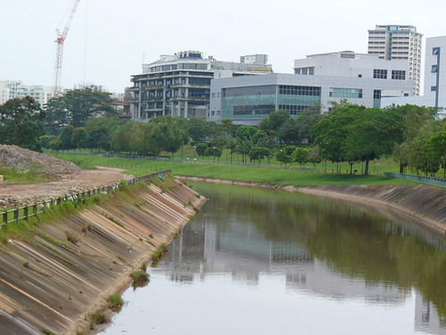
not something you would expect to see eh? hahaha with all the concretization of streams and rivers in Singapore, many of us assumed that rivers/streams look like this:


(source: Flickr, Jurong River, visible from the MRT towards Jurong East station)

The first thing i noticed about Binjai Stream is how clear its waters were:

you can totally see the streambed! it is sandy at the bottom, and the water, according to ChenKo, is one of the cleanest around (in terms of dissolved loads -ie. the ions present in the water - and suspended load -ie. the sediments in the water)

I believe that it is this clear as there has been little rainfall lately. During the monsoon months/heavy rainfall, sediments from the surroundings will be washed into the stream, clouding it up. Plus, there are hints of such sediment wash:

also, landslides are prevalent as you go higher upstream. This too, contributes to the amount of sediments in the river.

but i saw something that made me very upset again:

i saw SO MANY half-eaten Durians along the stream that if i ever see or smell a Durian again in my life i swear i will SCREAM. Im really fine with people picking durians and having a durian picnic at Bukit Timah. In fact, i think its a pretty cool and authentic way of eating Durians. but at least dump the shells and plastic bottles!!!

okay so i attempted bravely to ignore the atrocity and continued with our mission at hand:


this is willis measuring the pH of the water, which registered at about pH5.8, slight acidic.

Chen Ko taking a sample for further testing.

Later, we were joined by a group of grasscutters - wow they actually maintain this place!

its good that they are here to clear the path and stuff, but with them walking in the stream, it really murks up the waters at our testing site! look at the water, you can no longer see the streambed.

and theres me, testing the amount of Calcium in the water, the solution was supposed to be pinkish/violet:

#1 - note the clear-ness of the water, this sample was taken before the grasscutters came


#2 - note the murky quality of the water, this sample was taken after the grasscutters came

if you are wondering where the calcium comes from, it comes from the soil. Water (especially in natural streams like this) passes through different layers of the soil before reaching the river, a process we call Percolation, it dissovles and picks up different minerals. and calcium is one of them.

this is the end of our first station, and we move forward. Deeper into the forest, upstream of the river.

The stream looked pretty Friendly at first, flat and sandy riverbed, easy for walking (note willis's shoes are WHITE here):

later we were greeted with our first trial:


this is what i meant by "landslides during the wet season".

those muddy looking walls at the sides will fall if it gets saturated with water. the walls are there as the movement of the water cuts through the soil, and at the same time carry off the sediments. A process know as River Erosion.


Next, we came across this:

Fallen trees are really NOT a stream-trekker's bestfriend.

i assure you, this is NOT the only one we had to cross. i think there was one tree every 5 meters. it was awesome. i felt like Indianna Jones' minion! and at the same time, the river bed was getting all muddy and boggy-like.

however, everything paid off when we saw two small, mini, NATURAL 'waterfalls':
Please Click to Enlarge, small pictures do not do them justice!!!


#1

#2

well.. we climbed those waterfalls too. HAHAHAHAHA. i told you it was an interesting day! if there was more water - ie. higher stream discharge, say during a storm event, these 2 'waterfalls' could have been rapids!

we met some animals along the way. im sure theres a whole lot more, just that we were too preoccupied with the trees and the slippery rocks to notice them. im sorry!


This little toady here jumped on to my shoe! and i thought it was a piece of leaf.

and here's Jiayi's favourite thing in the world, a slug. we also saw one huge Golden-Orb Spider, similar to the ones at Chek Jawa, but it was too high up to take a proper picture ):


a Durian fell from one of the many Durian trees, woah did it make a loud sound. yes folks its the Durian season once again (im not a fan).

Finally, we reached the 'end' of the river:

there's this weird slab of concrete at the end. we were wondering what exactly is it. an old military check point? or some pipe connector that broke?

anyways we got on with work:

Chen Ko Testing the Turbidity (amount of suspended sediments) of the water. Which, registered a much higher reading than that downstream. Hence, there are higher levels of sediments here.

I did the test on Electrical Conductivity which (in laymen) implies the amount of IONS in the stream. This too, registered a higher reading than downstream.

higher amount of suspended load + higher amount of dissolved load = due to more upstream erosion??

anyways, i was all looking foward on the return trip - the same route of fallen trees, marching ants, slugs, leaping toadies and super cool waterfalls.

but chen ko knows another route! a much quicker one that would bring us back to civilization. and we emerge from the forest to this:

this is one of THE main source which contributes to the stream that we were following! we decided to go down and take a look:

WE FOUND A POND! two ponds, to be exact. 10 mins ago we were in that forest, by the way.

this pretty much concludes our water quality testing day. it was a great adventure, really.

You may be wondering why is Chenko collecting these data - he is simply doing so to keep a record of how our environment is behaving. These data may prove to be of great importance in the future, as over time, they could reveal a certain trend, especially when it concerns the water supply.

For the time being, i do hope that the Binjai Stream will remain the way it is - serene, peaceful and wild. untainted by urbanization and concretization (for most parts).
Love, Serene!


Special Thanks to:

Mr Kwok Chen Ko for taking us along with him on this amazing trip!
Mr Willis Sim for getting his shoes dirty (understatement of the century):


his shoes were originally white!

Thursday, June 11, 2009

Chek Jawa IV: Im a Tabloid Lover, check out these Chocolate Truffle Rocks.

if there is one place i really really really REALLY want to go in Singapore, that would be Pulau Sekudu.

or Frog's Island.The name came from a pretty erm, well.. strange legend of how Pulau Ubin was formed.

Apparently, one fine day, a pig, an elephant and a frog decide to engage in a swimming race to johor (i never knew that elephants and pigs can swim!). all 3 animals lost, and the frog turned into Pulau Sekudu, and the elephant + pig turned into Pulau Ubin.

okay that aside, Frog's Island is really a small, Granite islet next to Chek Jawa:


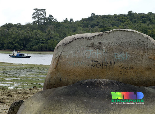
look at those rocks: the colors, the shape and the placings of the rocks - these arent random! they are carved out after millions of years of weathering.

Dont the rocks look like Chocolate truffle cakes? i believe that the white band is there as during high tide, the sea water covers that particular area, and wave action bleaches it (due to the salt content).. any thoughts?

what exactly is weathering?

in simple terms, its really the disintegration of rocks via natural elements such as water and heat from the sun.

Weathering and Erosion are different in a sense that Erosional processes MOVE materials away from their original spots and weathering does not do that.

i wldnt go into the ghastly details, though i would love to, you'd have to take A-Level geography for that!

I havent been onto the islet YET, as from what ive read, the NParks has made it now illegal to go onto the islet without a permit. For people have been abusing the islet by illegally fishing and harvesting marine life like oysters and clams. good going folks.

anyways, to give you an idea of how the rocks are like on the islet:

(source: Wildsingapore)
these rocks arent here to stay forever, eventually the elements will weather it away into nothing. so it would be good to take a look before they are really gone.


I understand the desire to leave your mark (for i was once an avid doodler on school tables), but OMG DONT PEOPLE GROW OUT OF IT? if you enjoy doodling, do it on a piece of paper.
(and john im sorry it says john, im sure its not you)

you can visit http://www.simplygreen.com.sg/ubin/frogisle.htm for some REALLY GOOD PICTURES. i was totally blown away.

This rock is found on the main island of P.Ubin:


the vertical lines are really lines of weakness which would allow the entry of water for further weathering.

this is an example of how wave actions and water weather rocks and give them distinctive shapes (once again, ignore the two mad people)- if the rocks were bigger and the waves were stronger, the curved area would have formed a lagoon.

ARRRGHHH! even the rocks arent spared of litter!!!

i know many people do not understand my obsession with rocks.

but if you think about it, rocks are really little bits of historical records of the changes that earth went through, take for example this:

(photo: Vithya)
this is something my friend Vithya saw in India, its termed "Krishna's butterball" - a granite rock perched on a smooth slope. yet it doesnt roll! isnt it a wonder?

no one has any idea how it got there, for its composition is totally different from the other rocks around it. some suggested that it is brought there by Glacial Erosion - which has the capcity to move huge materials. but that would mean that india had a totally diffferent climate in the past! see what i mean now?


(photo: John)
and these are some limestone/chalk cliffs that John visited in Dover, England. these cliffs, too, take millions of years before they become cliffs.

so the next time you kick a stone out of your way, remember, you are really kicking bits of Earth's history!

<3 serene!