Today is probably one of the most Interesting (note the capital I) days of my life.
We met up with Mr. Kwok Chen Ko, a lecturer from Singapore Poly, who does a lot of work on the water quality of streams in Singapore. He is super! Chen Ko invited two of us freshfaced-bushytailed-brighteyed-first-year-going-on-second geography students to a water quality monitoring trip at BINJAI STREAM.
that stream is really ulu. it is set pretty deep in the heart of Bukit Timah nature reserve, not something that hikers usually stumble upon. Reason being:

this is the entrance to the stream.
we walked through one of these tunnels in order to get to the stream. and there were things flying passed our faces/heads (okay dont let your imagination run wild, they are really just swallows not blood-sucking bats) and strange creatures crawling on the walls (okay they are really just lizards and gekkos). The water in there was nearly ankle to calve deep.
oh and, by the way, the tunnel goes under the PIE expressway.
after the tunnel:

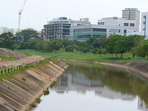
not something you would expect to see eh? hahaha with all the concretization of streams and rivers in Singapore, many of us assumed that rivers/streams look like this:
 (source: Flickr,
 you can totally see the streambed! it is sandy at the bottom, and the water, according to ChenKo, is one of the cleanest around (in terms of dissolved loads -ie. the ions present in the water - and suspended load -ie. the sediments in the water)
 also, landslides are prevalent as you go higher upstream. This too, contributes to the amount of sediments in the river.
 i saw SO MANY half-eaten Durians along the stream that if i ever see or smell a Durian again in my life i swear i will SCREAM. Im really fine with people picking durians and having a durian picnic at Bukit Timah. In fact, i think its a pretty cool and authentic way of eating Durians. but at least dump the shells and plastic bottles!!!
 this is willis measuring the pH of the water, which registered at about pH5.8, slight acidic.
 Chen Ko taking a sample for further testing.
 its good that they are here to clear the path and stuff, but with them walking in the stream, it really murks up the waters at our testing site! look at the water, you can no longer see the streambed.
 if you are wondering where the calcium comes from, it comes from the soil. Water (especially in natural streams like this) passes through different layers of the soil before reaching the river, a process we call Percolation, it dissovles and picks up different minerals. and calcium is one of them.
 later we were greeted with our first trial:
this is what i meant by "landslides during the wet season".
those muddy looking walls at the sides will fall if it gets saturated with water. the walls are there as the movement of the water cuts through the soil, and at the same time carry off the sediments. A process know as River Erosion.
Next, we came across this:
 Fallen trees are really NOT a stream-trekker's bestfriend.
i assure you, this is NOT the only one we had to cross. i think there was one tree every 5 meters. it was awesome. i felt like Indianna Jones' minion! and at the same time, the river bed was getting all muddy and boggy-like.
however, everything paid off when we saw two small, mini, NATURAL 'waterfalls':
Please Click to Enlarge, small pictures do not do them justice!!!
#1
 #2
#2 well.. we climbed those waterfalls too. HAHAHAHAHA. i told you it was an interesting day! if there was more water - ie. higher stream discharge, say during a storm event, these 2 'waterfalls' could have been rapids!
we met some animals along the way. im sure theres a whole lot more, just that we were too preoccupied with the trees and the slippery rocks to notice them. im sorry!
 This little toady here jumped on to my shoe! and i thought it was a piece of leaf.
 and here's Jiayi's favourite thing in the world, a slug. we also saw one huge Golden-Orb Spider, similar to the ones at Chek Jawa, but it was too high up to take a proper picture ):
a Durian fell from one of the many Durian trees, woah did it make a loud sound. yes folks its the Durian season once again (im not a fan).
Finally, we reached the 'end' of the river:
 there's this weird slab of concrete at the end. we were wondering what exactly is it. an old military check point? or some pipe connector that broke?
anyways we got on with work:
 Chen Ko Testing the Turbidity (amount of suspended sediments) of the water. Which, registered a much higher reading than that downstream. Hence, there are higher levels of sediments here.
 I did the test on Electrical Conductivity which (in laymen) implies the amount of IONS in the stream. This too, registered a higher reading than downstream.
higher amount of suspended load + higher amount of dissolved load = due to more upstream erosion??
anyways, i was all looking foward on the return trip - the same route of fallen trees, marching ants, slugs, leaping toadies and super cool waterfalls.
but chen ko knows another route! a much quicker one that would bring us back to civilization. and we emerge from the forest to this:
 this is one of THE main source which contributes to the stream that we were following! we decided to go down and take a look:
 WE FOUND A POND! two ponds, to be exact. 10 mins ago we were in that forest, by the way.
 this pretty much concludes our water quality testing day. it was a great adventure, really.
You may be wondering why is Chenko collecting these data - he is simply doing so to keep a record of how our environment is behaving. These data may prove to be of great importance in the future, as over time, they could reveal a certain trend, especially when it concerns the water supply.
For the time being, i do hope that the Binjai Stream will remain the way it is - serene, peaceful and wild. untainted by urbanization and concretization (for most parts).
Love, Serene!
Special Thanks to:
Mr Kwok Chen Ko for taking us along with him on this amazing trip!
Mr Willis Sim for getting his shoes dirty (understatement of the century):